 |
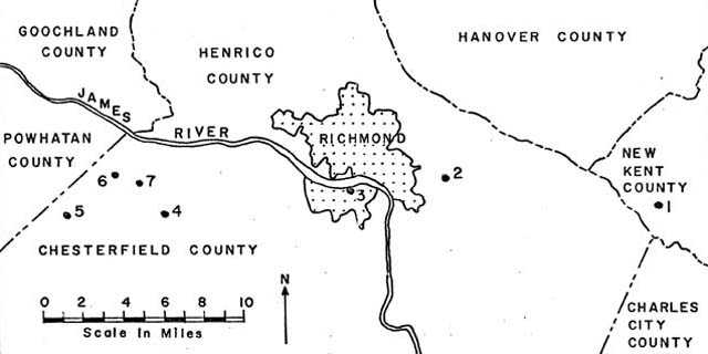
Figure 1. Index map of the Richmond-Midlothian area showing locations of field conference stops. |
FROM:
ELEVENTH ANNUAL FIELD CONFERENCE OF THE ATLANTIC COASTAL PLAIN GEOLOGICAL ASSOCIATION GUIDEBOOK
PART 2
GEOLOGY OF THE UPLAND GRAVELS NEAR
MIDLOTHIAN, VIRGINIA
by
Bruce K. Goodwin
and
Gerald H. Johnson
Prepared for the Eleventh Annual Field Conference of
the Atlantic Coastal Plain Geological Association
October 17 and 18, 1970
[Part 1 not reproduced]
PART II
Guidebook To The
GEOLOGY OF THE UPLAND GRAVELS
NEAR
MIDLOTHIAN, VIRGINIA
By
Bruce K. Goodwin
and
Gerald H. Johnson
Department of Geology
The College of William and Mary
Williamsburg, Virginia
CONTENTS
| Page | |
| Introduction | 1 |
| Acknowledgments | 3 |
| Geography and Morphology | 3 |
| Regional Stratigraphy and Structure | 5 |
| The Midlothian Gravels | 6 |
| The Carolina Bay | 8 |
| Bibliography | 14 |
| Road Log | 18 |
ILLUSTRATIONS
| Figures | Page | |
| 1. | Index map of the Richmond-Midlothian area showing field conference stops. | 2 |
| 2. | Map showing the Carolina Bays and the upland gravels in the southeastern corner of the Midlothian quadrangle. | 9 |
| 3. | Map showing the Carolina Bays and the upland gravels in the southwestern corner ofthe Bon Air quadrangle. | 10 |
| 4. | Generalized geologic section through a segment of the upland gravels. | 11 |
| 5. | Sketch of an exposure of the upland gravels at Stop No. 4. | 24 |
| 6. | Sketch of an exposure of the upland gravels at Stop No. 5. | 28 |
| 7. | Sketch of an exposure of the upland gravels at Stop No. 6. | 30 |
INTRODUCTION
This part of the guidebook deals primarily with the geology of a remnant of high level gravels overlying bedrock of the Piedmont province in the vicinity of Midlothian, Virginia. Midlothian is located approximately 13 miles west of Richmond and four miles south of the James River (Fig. l). In this area, coarse upland gravels overlie igneous end metamorphic rocks of Precambrian (?) and Paleozoic age and sedimentary rocks of Triassic age. the gravels, which represent only the remnants of formerly more extensive gravel deposits in this area, cap more than 20 square miles of upland. In this guidebook they will be referred to as the Midlothian gravels.
Circular to elliptical depressions occur on relatively undissected tracts of upland gravels at altitudes of 350 to 370 feet. The depressions which are less than 15 feet deep are commonly bounded by a raised rim. They vary in maximum diameter from a few hundred feet to more than three quarters of a mile. Their centers are often swampy due to the lack of external drainage. These depressions are tentatively designated as Carolina Bays.
No known field trips have dealt with these upland gravels or their surficial depressions. The senior author became acquainted with them while engaged in quadrangle mapping for the Virginia Division of Mineral Resources. This mapping was undertaken to investigate the bedrock of the area and sediments of the Coastal Plain were far from the mind of the investigator. As work proceeded it became apparent that the gravels could not be neglected. However, because of the senior author's inclination toward Piedmont geology, this guidebook must be taken as an attempt to show and describe some previously unknown geological features. Little attempt will be made here to provide definitive conclusions. Hopefully the participants in the field trip, through their more thorough knowledge of the nature of sediments, wilt be able to provide more insight into the complexities involved.
Starting from Norfolk, the itinerary of the fiend trip takes the participant across the Coastal Plain of the York-James Peninsula to the City of Richmond. The detailed road log begins near Williamsburg at the Camp Peary-Williamsburg exit of I-64. Much of the geology along I-64 to the east of this point is described by Johnson (1969). Two stops in the Coastal Plain province will allow the participants to compare gravel deposits there with the upland gravels around Midlothian. The field trip route will then cross the James River at the Fall Zone and proceed to the area underlain by the upland gravels. Three stops will be made to examine the upland gravels and their stratigraphic relationship with the underlying rocks. a final stop will provide a detailed look at a section through a portion of a Carolina Bay.
|
Figure 1. Index map of the Richmond-Midlothian area showing locations of field conference stops. |
ACKNOWLEDGMENTS
The authors gratefully acknowledge the help of Mr. Harold L. Mathews, a soil scientist at Virginia Polytechnic Institute, for first bringing the upland gravels to their attention. He spent two days in the field with the authors and provided help in finding new localities and in giving insight into various problems. Our colleagues at the College of William and Mary, Dr. Kenneth F. Dick and Dr. Stephen C. Clement gave helpful suggestions concerning many aspects of the study. Miss Patricia B. Wendell, a graduate of William and Mary, assisted in laboratory studies on the upland gravels. Special thanks must go to Mrs. Mary E. Magary who patiently typed and compiled the manuscript.
GEOGRAPHY AND MORPHOLOGY
The City of Richmond straddles the Fall Zone and has been the center of eastern Virginia's commerce and industry since colonial times. It is the seat of Virginia's government and was the capital of the Confederacy during the war between the States. Near Midlothian agriculture is still active and some minor logging occurs. Although this town was once an active coal mining center, the mines have fallen into disuse since the 1930's and coal is no longer produced. With the rapid urbanization of Richmond and the expanding web of its suburbs, numerous housing developments are being built ever closer to Midlothian. Near the town several woodland tracts have recently been developed for home sites. The next few years will undoubtedly signal a rapid change from a rural environment to a residential area with its supportive businesses.
The upland gravels around Midlothian occur on the generally rolling topography of the eastern Piedmont of Virginia. Maximum relief in the area is approximately 300 feet between the floodplain of the James River and the highest upland surface veneered by gravels. Upland surfaces covered by gravels are relatively flat and undissected. The edge of the gravel cover is usually marked by a pronounced steepening of hill slopes where the gravels have resisted erosion more effectively than the underlying, more readily weathered and easily eroded lithologies.Igneous and metamorphic rocks of Precambrian and/or Paleozoic age are exposed in many areas and crop out eastward for about fourteen miles to the Fall Zone. There they are nonconformably overlain by Coastal Plain sediments of Cretaceous and Cenozoic age.
From the Fall Zone the Coastal Plain descends eastward from an elevation of about 170 feet to sea level in a series of steps. long controversy has surrounded the number, origin, and stratigraphy of these terraces or steps and the scarps bounding them. A discussion of the various ideas dealing with the classification and interpretation of these various levels is beyond the scope of this guidebook. A summary of the several concepts on this topic is provided by Johnson (1969).
The high level, upland gravels of the Midlothian area were noted by Shaler and Woodworth (1899) in their classic work on the Triassic rocks of the Richmond basin. Dar ton (1911) described the high level gravels in the Richmond area referring to them as the Lafayette formation of Pliocene(?) age, using the name proposed by Shattuck (1906). However, due to the ambiguous use of the term Lafayette in relation to high level gravels by many different authors, Clark (1915) suggested the name of Brandywine be used. This name was proposed for both the plain and the gravels as shown on the upland surfaces near Brandywine, Maryland. In the detailed study by Wentworth (1930), the name Brandywine was retained for the gravels in eastern Virginia. Wentworth also mentioned an older and higher terrace formation which he named the Tenley Formation, but did not elaborate upon it in his 1930 report. One strong contrast noted by Wentworth (1930) between the Brandywine gravels and lower, younger gravels was the absence of striated boulders and cobbles in the higher level gravels and the presence of such striated boulders and cobbles in the lower gravels. This led Wentworth to conclude that the Brandywine gravels were Pre-Pleistocene (Pliocene ?) in age whereas the lower gravels were deposited during Pleistocene time.
Hack (1955) provides a good summary of both the nomenclature and arguments concerning the origin of the upland gravels of the inner Atlantic Coastal Plain. In his detailed study of the Brandywine type locality, Hack retains the name "Brandywine" for the upland gravel deposits, but refutes the concept of their formation as marine terrace deposits formed during former high stands of sea level. He believed that the gravels are of fluvial origin. Although he considered the Brandywine to be Pliocene(?) in age, Hack suggested that deposition of the gravels began in the Miocene or Pliocene and ended in the Pleistocene.
In a broad study of upland gravels of the southern part Of the Atlantic Coastal Plain, Doering (1960) correlated the gravels west of the Fell Zone in Virginia with the early Pleistocene Citronelle Formation of the eastern Gulf Coast region. He included within the Citronelle all of the upland gravels above the level of the 20-foot plain on the Sunderland surface. For Virginia, he suggested that the Citronelle Formation correlated with the Tenley Formation of Wentworth (1930).
The upland gravels around Midlothian are isolated and have been truncated by erosion on all sides. They are completely surrounded by exposures of much older rocks which lack a gravel cover except possibly some colluvial gravels. Therefore, the Midlothian gravels cannot be directly correlated with the other known upland gravels. Mathews (1955) referred to the gravels in Chesterfield County as the Brandywine-?-Citronelle Formation and stated that they underlay a terrace surface which rose to elevations of more than 400 feet and which was bounded by an escarpment on the east at an elevation of about 270 feet.
Younger gravels do occur at lower elevations between Midlothian and the James River to the northwest, on the north side of the James River directly north of Midlothian, and between Midlothian and Richmond to the east. These underlie gently inclined fluvial terrace surfaces which rise to elevations of more than 250 feet and their base is at an elevation of about 150 feet near the James River. North of Midlothian these younger gravels appear to be deposits of the ancestral James River. Mathews (1965) thought that they belonged to the Sunderland Formation. The present authors would prefer to place these younger gravels with the Brandywine Formation. Nowhere are the lower gravels in direct contact with the older upland gravels which underlie Midlothian.
Although the Midlothian gravels may correlate with the Brandywine Formation, due to their high elevation they could be placed in the Citronelle Formation. However, they could also well be correlative with the Tenley Formation, or may represent a previously unrecognized unit. No attempt to establish a correlation will be made in this guidebook.
REGIONAL STRATIGRAPHY AND STRUCTURE
The regional stratigraphy and structure of the eastern Coastal Plain of the York-James Peninsula is summarized in Bick and Coch (1969) and in Johnson (1969). These reports deal with the Miocene sediments of the St. Marys and Yorktown Formation and with Pleistocene sediments us to the level of the 120 foot plain.
East of Richmond the Calvert Formation of Miocene age crops out in the bottom of valleys. It is usually disconformably overlain by gravels at an elevation averaging about 140 feet. Nearer the Fall Zone, in the eastern portion of, the City of Richmond, Darton (1911) reported outcrops of older Tertiary and Cretaceous formations. According to Carton the sandy diatomaceous clay of the Calvert Formation lies unconformably on the dark sand of the Aquia Formation of the Pamunkey Group. An unconformity separates the Aquia from the underlying cross-bedded, gravelly, arkosic sand of the lower Cretaceous Patuxent Formation.
The Mesozoic and Cenozoic sediments dip gently eastward and lie nonconformably upon the slightly irregular surface of the igneous and metamorphic complex of the Piedmont. The stratigraphy and structure of the igneous and metamorphic rocks will not be discussed here as it is not considered to be relevant to the major emphasis of this guidebook. Following deformation of the crystalline rocks, Triassic sediments were deposited and are preserved in isolated, donwnfaulted basins. The Richmond basin contains arkosic sandstone, shale, coal, and local conglomerates, all of Triassic age. The Triassic sediments have been faulted, slightly folded, and intruded by thin disease dikes. The crystalline rocks and Triassic sediments have both been truncated by erosion and upland gravels have been deposited unconformably upon these eroded, at times channelled, surfaces. Of the several upland gravel deposits which have Been recognized, the Midlothian gravels are the highest and the oldest in this area. They lie directly across the contact between Triassic sediments and crystalline rocks. It does not appear that the gravel deposits have been extensively tilted or deformed subsequently to their deposition.
THE MIDLOTHIAN GRAVELS
The Midlothian gravels are considered to be the oldest gravels in this region and occur as upland remnants isolated from the younger, lower gravels. The edges or the upland gravel have been dissected by tributaries of the James and Appomattox Rivers, leaving an escalloped elliptical tract of upland gravels. On the east the gravels are truncated by erosion producing an escarpment. The gravels range in thickness from a feather edge. to more than 40 feet. The average thickness is approximately 20 feet. The gravels in the Midlothian area reach an altitude of 370 feet, increase to over 400 feet to the west, and decrease to less than 300 feet on the east.
The upland gravels unconformably overlie igneous and metamorphic rocks of Precambrian(?) and/or Paleozoic age and arkose, shale and coal of Triassic age. In most Places the older Piedmont rocks were weathered to a saprolite before the gravels were deposited. Although locally the contact between the gravels and underlying rocks exhibits more than 20 feet of relief due to channelling, the surface of unconformity dips gently to the east or southeast at approximately nine feet per mile. Mixing of weathered older rock with the gravels at the contact is net uncommon.
Mathews (1965) subdivided the upland gravels into a lower gravel member and an upper loam member. Our studies indicate that a discontinuous basal cobble zone and overlying thick clay underlie the gravel member reported by Mathews. The basal cobble zone is one to four cobbles thick and is commonly solidly cemented by iron oxide to form a ferricrete zone. The cobbles and pebbles in this zone are well-rounded, tend to be discoid, and lack any pronounced orientation. The cobble or ferricrete zone is overlain by a yellowish-brown clay bed up to four feet thick. The clay bed is conformably overlain by the gravel member of the Midlothian gravels.
The most striking feature of the Midlothian gravels is the thick gravel member. The gravel member, which ranges in thickness from zero to nearly 40 feet, is composed of abundant pebbles and cobbles in a sandy matrix containing variable amounts of clay. Although cobbles up to nine inches in maximum diameter were observed, the average cobble measures two to three inches in diameter. The cobbles are well-rounded and sphericity varies from low to high. Discoid cobbles tend to be oriented parallel to the bedding. No distinct graded bedding or imbrication of cobbles or pebbles was observed. Bedding within the gravel member is indistinct or lacking.
The clasts are variable in composition but most are of some variety of quartz. Vein quartz, massive quartz, quartzite and quartz sandstone are the dominant lithologies comprising the clasts. A few clasts of other metamorphic rocks, igneous rocks, and chert constitute a minor portion of the gravels. The chests are stained a reddish-brown on the surface but are unstained on freshly broken surfaces. The matrix containing the pebbles and cobbles may be very light brown. Locally the matrix may be composed principally of clay. The clay appears to be derived from the decomposition of feldspar, alleviated from overlying beds, and to a lesser extent primary. Weathering of the gravel member has resulted in the formation of iron oxide giving the gravels a yellowish-brown or reddish-brown color, incipient cementation with iron oxides, silica, and clays, and the decomposition of clasts to form clays from feldspars and quartz sand from quartzite and sandstone cobbles and pebbles.
The upper loam member is exposed in low road cuts and at the top of most major gravel exposures. The loam member rests conformably on the gravel in a gradational contact. The loam member is characterized by its deeps reddish-brown color, and its fine matrix with scattered siliceous cobbles and pebbles. It ranges in thickness from 12 feet to a featheredge.
No fossils have been found within the gravels to aid in determining their age or their origin. Since they occur as a completely isolated upland remnant, direct correlation with other gravels is impossible and compounds the problems. The authors feel that the Midlothian grovels are fluvial in ordain. This is suggested by the sedimentary features of the deposits, the stratigraphic sequence, the absence of fossils, the gravel's apparent filling of channels cut into weathered bedrock, the deep weathering of bedrock prior to gravel deposition, and the topographic expression of the gravels. The age of the gravels could be between late Mesozoic (Cretaceous) and late Tertiary. Assuming that little or no tectonic activity has caused regional uplift in this area during the Pleistocene, the deep weathering profile and the isolated topographic expression of the gravels preclude assigning them Pleistocene age.
THE CAROLINA BAYS
The flat, undissected upland surface of the Midlothian gravels is marked by numerous elliptical to subcircular depressions or basins. These basins were first reported bait Johnson and Goodwin (1967). Over twenty such basins have been recognized in this area and nineteen are shown on Figures 2 and A. The basins have formed on the Midlothian gravels and the basin sediments are immediately underlain by course gravels. The elevation of the basin floors is between 345 to 360 feet above sea level and a low ridge or rim surrounds the basins (Fig. 4). This rim from five to 15 feet high, is most commonly best developed on the south and east sides of the basins. The basins range in size frown a few hundred feet to more than three quarters of a mile and where elliptical, their major axis trends from N 60° W to 80° W. The undrained basins contain organic-rich, fine-grained sediments and support a hygrophilous flora. A few of the basins have been breached by streams and are being drained. Because of the similarities between these depressions and the well-studied elliptical depressions known as Carolina Bays on the central and southern Atlantic Coastal Plain of North America, the authors have adopted the same name for the shallow basins on the Midlothian gravels.
A section from the interior through the rim of one of the Carolina Bays in this area is described in Stop No. 7 of the road log of this guidebook end only an outline is presented here. In general the section shows that the rim is underlain dominantly by sand containing some pebbles but only very minor amounts of clay. Rarely cobbles or pebbles occur within the sand. A pronounced decrease in sand occurs from the rim toward the bay's interior and massive, brownish-gray, silty clay with a few scattered quartz pebbles becomes the dominant sediment. This clay is in direct contact with the underlying gravels. The lateral transition from sand to clay is gradational but occurs within a distance of less than 200 feet from the rim.
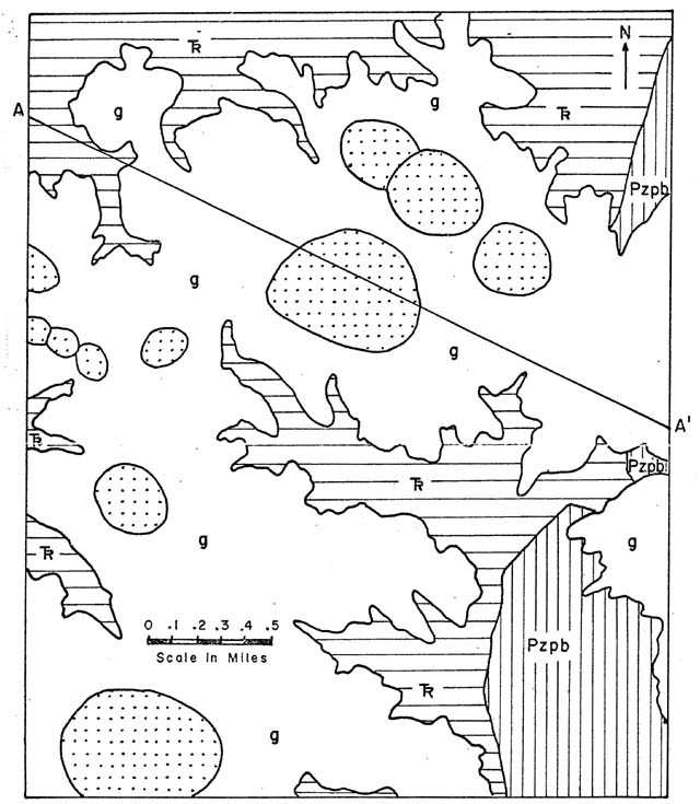 |
Figure 2. Map showing the Carolina Bays and the upland gravels in the southeastern corner of the Midlothian quadrangle. Triassic sedimentary rocks = horizontal ruling; igneous rocks = vertical ruling; Midlothian gravels = plain; Carolina Bays = stippled. |
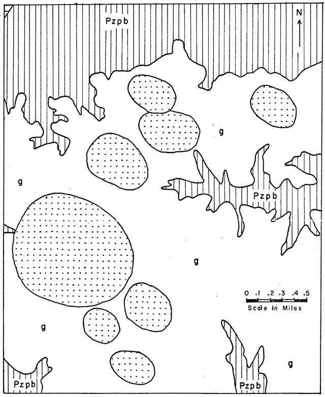 |
| Figure 3. Map showing the Carolina Bays and the upland gravels in the southwestern corner of the Bon Air quadrangle. Triassic sedimentary rocks =-horizontal ruling; igneous rocks = vertical ruling; Midlothian gravels = plain; Carolina Bays = stippled. |
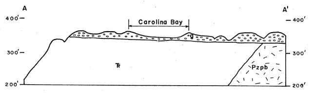 |
| Figure 4. Generalized geologic section through a segment of the upland gravels. Section corresponds to A-A' of Figure 2. |
A reconnaissance survey of the surrounding region revealed that these basins are restricted to the upland surfaces of the Midlothian gravels. No evidence was found of similar basins in Piedmont areas without a gravel veneer or in areas which have been severely dissected by erosion.
Apparently the development of the bays is in no way related to the Piedmont bedrock which underlies the Midlothian gravels. Some of the bays have formed on gravels overlying granite, and some have developed on gravels overlying Triassic shale, sandstone, and coal measures (Fig. 4). To the author's knowledge, these are the first Caroline Bays reported west of the eastern Coastal Plain in Virginia and Probably are the first reported from an area outside of the sand-covered Coastal Plain or its erosional remnants.
The Carolina Bays of the Atlantic Coastal Plain and the numerous speculations concerning their origin have provided a long and lively debate among many workers. Descriptions of the bays and summaries of some of the major hypotheses on bay development are given by Cooke (1934, 1954), Johnson (1942), Melton (1950), Murray (1961), Prouty (1952), Robertson (1962), and Thom (1970) as well as many others. Therefore there is little need to reiterate the descriptions and arguments here. A summary of the major origins forwarded for Carolina Bay formation include: meteorite impact; solution; submarine scour and subsequent wind action; artesian springs and ground water action; the action of wind and currents on shorelines; rotation of the earth aided by currents and wind; the schooling of fish around fresh-water springs on the continental shelf; and possibly the meandering of streams.
The authors do not desire to provide a discussion on the origin of the bays around Midlothian until more detailed investigations have been conducted. Two different environments appear plausible for the bay formation, (1) the broad floodplains of streams at a time when the James River and Appomattox River flowed over surfaces at much higher elevations prior to the cutting of their present valleys, and (2) a shallow marine environment when sea level was at an elevation of from 345 to 380 feet above present day sea level. Since we ascribe a fluvial origin to the gravels, the second alternative appears less likely in the case of the Piedmont Carolina Bays. If the bays developed on floodplains of the ancestral James River, they could have been formed at any time between the late Mesozoic and the late Tertiary, since the James River appears to have occupied its present channel throughout the Pleistocene Epoch.
At the present time, we are unable to assign a specific age to the Midlothian gravels because of the uncertainties of Tertiary and Mesozoic tectonics, lack of fossil evidence, and the isolated nature of the upland gravels. However, the deep weathering profile of the gravels and their isolated nature suggest that the upland gravels are older than Pleistocene and possibly older than late Tertiary.
SELECTED BIBLIOGRAPHY
Barrell, J., 1920, The Piedmont terraces of the northern Appalachians: Am. Jour. Sci., 4th ser., vol. 49, p. 227-258, 327-362, 407-428.
, 1925, Marine and terrestrial conglomerates: Geol. Soc. Amer. Bull., vol. 36, p. 279-342.
Bick, K.F., and Coch, N.K., 1969, Geology of the Williamsburg, Hog Island, and Bacon Castle Quadrangles, Virginia: Virginia Division of Mineral Resources, Rept. Inv. 18, 28 p.
Cederstrom, D.J., 1957, Geology and ground-water resources of the York-James Peninsula, Virginia: U.S. Geol. Surv. Water Supply Paper 1361, 237 p.
Clark, W.B., and Miller, B.L., 1906, A brief summary of the geology of the Virginia Coastal Plain, in Ries, Heinrich, Clay deposits of the Virginia Coastal Plain: Va. Geol. Surv. Bull . 2, pt. 1, p. 12-24.
, 1912, The physiography and geology of the Coastal Plain province of Virginia: Vs. Geol. Surv. Bull. 4, 274 p.
, 1915, The Brandywine formation of the Middle Atlantic Coastal Plain: Am. Jour. Sci., 4th ser., vol. 40, p. 499-506.
Colquhoun, D.J., 1965, Terrace sediment complexes in Central South Carolina: Atlantic Coastal Plain Geol. Assoc. Guidebook, Field Conference, 1965, 62 p.
Cooke, C W., 1930, Correlation of Coastal terraces: Jour. Geol., vol. 38, p. 577-589.
, 1931, Seven coastal terraces in the Southeastern United States: Washington Acad. Sci. Jour., vol. 21, p. 503-513.
, 1934, Discussion of the origin of the supposed meteorite scars of South Carolina: Jour. Geol., vol. 42, p. 88-96.
, 1936, Geology of the Coastal Plain of South Carolina: U.S. Geol. Surv. Bull. 867, 196 p.
, 1940, Elliptical bays in South Carolina and the shape of eddies: Jour. Geol., vol. L43, p. 205-211.
, 1943, Geology of the Coastal Plain of Georgia: U.S. Geol. Surv. Bull. 341, 121 p.
, 1952, Sedimentary deposits of Prince Georges County end the District of Columbia: Maryland Dept. of Geology, Mines, and Water Resources Bull. 10, p. 1-53.
, 1954-, Carolina bays and the shapes of eddies: U.S. Geol. Surv. Prof. Paper 254, p. 195-206.
, 1958 Pleistocene shore lines in Maryland: Geol. Soc. timer., Bull., vol. 69, no. 9, a. 1187-1189.
Darton, N.H., 1891, Mesozoic and Cenozoic formation in eastern Virginia and Maryland: Geol. Soc. Amer. Bull., vol. 2, p. 431-450.
, 1894, Outline of Cenozoic history of a portion-of the middle Atlantic slope: Jour. Geol., vol. 2, p. 568-587.
, 1911, Economic Geology of Richmond, Virginia and vicinity: U.S. Geol. Surv., Bull. 483, 48 p.
, 1939, Gravel and sand deposits of eastern 'Maryland adjacent to Washington and Baltimore: U.S. Geol. Surv. Bull. 906-A, p. 1-42.
, 1951, Structural relations of Cretaceous and Tertiary formations in part of Maryland cod Virginia: Geol. Soc. Amer. Bull., vol. 62, p. 745-780.
Doering, J., 1960, Quaternary surface formations of southern pert of Atlantic Coastal Plain: Jour. Geol., vol. 68, p. 182-202.
Dryden, A.L., 19,5, Structure of the Coastal Plain of southern Maryland: Am. Jour. Sci., 5th Ser., vol. 30, p. 321-342.
Flint, R.F., 1940, Pleistocene features of the Atlantic Coastal Plain: Am. Jour. Sci., vol. 238, p. 757-787.
Hack, J.T., 1955, Interpretation of erosional topography in humid temperate regions: Amer. Jour. Sci., vol . 258-A, p. 80-97.
, 1955, Geology of the Brandywine area end origin of the upland of southern Maryland: U.S. Geol. Surv., Prof. Paper 267-A, p 1-43.
Johnson, B.L., 1907, The terraces of the Maryland Coastal Plain: Science, New ser., vol. 26, p. 640-642.
Johnson, D.W., 1942, The origin of the Carolina Bays: Columbia University Press, New York, 341 p.
Johnson, G.H., and Goodwin, B.K., 1967, Elliptical depressions on undissected highland gravels in northern Chesterfield County, Virginia (Abs): Va. Jour. Sci., vol. 18, no. 4, p. 166.
Johnson, G.H., 1969, Guidebook to the Geology of the York-James Peninsula and South Bank of the James River: Guidebook No. 1, Dept. of Geology, College of William and Mary.
MacNeil, F.S., 1950, Pleistocene shore lines in Florida and Georgia U.S. Geol. Surv. Prof. Pacer 221-F, p. 95-107
Matthews, H.L., Hodges, R.L., and Amos, D.F., 1965, Some geological and geomorphological observations of Chesterfield County (Abs): Va. Aced. Sci. Proc., vol. 16, no. 4, p. 380-381.
McGee, W.J., 1891, The Lafayette formation: U.S. Geol. Surv., 12th Ann. Rept., pt. 1, p. 347-521.
Melton, F.A., 1950, The Carolina Bays: Jour. Geol., vol. 58, p. 126-134.
Moore, W.E., 1956, Stratigraphy of Pleistocene terrace deposits in Virginia (Abs): Geol. Soc. amen Bull., vol. 67, p. 1755.
Murray, G., 1961, Geology of the Atlantic and Gulf Coastal province of North America: Harper and Bros., New York, 692 p.
Oaks, R.Q., and Coch, N.K., 1963, Pleistocene sea levels, southeastern Virginia: Science, vol. 140, p. 979-983.
Potter, P.E , 1955, The petrology and origin of the Lafayette Gravel, Part 1. Mineralogy and petrology: Jour. Geol., vol. 63, p. 1-38.
Prouty, W.F., 1935, "Carolina Bays" and elliptical lake basins: Jour. Geol., vol. 43, p. 200-207.
, 1952, Carolina bays-and their origin: Geol. Soc. Amer. Bull., vol. 63, p. 167-224.
Richards, H.G., 1950, Geology of the Coastal Plain of North Carolina: Amer. Philos. Soc. Trans., vol. 40, p. 183.
, 1959, Recent studies on the Pleistocene of the South Atlantic Coastal Plain: Southeastern Geology, vol. 1, no. 1, p. 11-21.
, 1962, Studies on the marine Pleistocene: Amer. Philos. Soc. Trans., vol. 52, p. 1-141.
, and Judson, S., 1965, The Atlantic Coastal Plain and the Appalachian Highlands in the Quaternary: In The Quaternary of the United States, Princeton Univ. Press., Princeton, N.J., p. 129-136.
Robertson, E.C., 1362, The Carolina: Bays and Emergence of the Coastal Plain of the Carolinas and Georgia: U.S. Geol. Surv. Prof. Paper 450-c; p. 87-90.
Rosen, N.C., 1969, Heavy minerals and size analysis of the Citronelle Formation of the Gulf Coastal Plain: Jour. Sed. Pet., vol. 39, no. 4, p. 1552-1565.
Shaler, N.S., and Woodworth, J.B., 1899, Geology of the Richmond Basin, Virginia: U.S. Geol. Surv., 19th Ann. Rept., pt. 2, p. 385-515.
Shattuck, G.B., 1906, The Pliocene and Pleistocene deposits of Maryland: Maryland Geol. Surv., Pliocene and Pleistocene, p. 21-137.
Stephensen, L.W., 1916, The Coastal Plain of North Carolina; the Cretaceous, Lafayette, and Quaternary formations: North Carolina Geol. Surv., Bull. 3, p. 73-171, 258-290.
Thom, 3.G., 197G, Carolina bays in Horry and Marion Counties, South Carolina: Geol. Soc. Amer. Bull., vol. 81, In. 783-814.
Wentworth, C.K., 1928, Striated cobbles in the southern States: Geol. Soc. Amer. Bull., vol. 39, p. 941-953.
, 1930, Sand and gravel resources of the Coastal Plain of Virginia: Virginia Geol. Surv. Bull. 32, 146 p.
ROAD LOG
| Mileage Between Points |
Road log begins at the interchange of I-64 with Va. 16S, northeast of Williamsburg. Proceed west on I-64. I-64 crosses a dissected portion of the 90-foot plain. |
| 3.7 | Ascend the Surry sear p from the 90-foot plain to the 120-foot plain. The 120-foot plain (terrace) is extensively dissected because of its greater age and its proximity to both the York River and the Chickahominy River. |
| 6.4 | Stoplight at the junction of U.S. 60 and Va. 168. Continue west (straight) on U.S. 60. |
| 4.0 | Route 60 descends into the valley of Diascund Creek. Paired 45-foot terraces lie on both sides of the creek. |
| 1.5 | Enter the town of Lanexa. Continue west on U.S. 60. Ascend scarp to uplands. |
| 2.4 | At the crest of the hill, the 120-foot plain is visible on the opposite side of the valley. Descend to a 45-foot terrace which is one of the paired terraces parallel to the Chickahominy River. These terraces are continuous downstream with terraces along the James River and presumably represent a Norfolk high-stand of sea level. The 45-foot terrace extends westward along the Chickahominy River to the vicinity of Bottoms Bridge where it merges with the present day floodplain of the Chickahominy River. |
| 3.0 | For the next mile the scarp on the right (north) represents the valley wall of the Chickahominy River during Norfolk time. |
| 3.3 | Stoplight at Providence Forge. Continue west on U.S. 60. |
| 3.0 | Ascend the valley wall to the uplands. This plain, which ranges in attitude from 100 feet near modern streams to over 140 feet in the axial region of the peninsula, is dissected by stream erosion. |
| 4.6 | Descend onto the 45-foot terrace. |
| 2.0 | Stoplight et the junction of U.S. 60 and Va. 33. Turn right (northeast) on Va. 33. |
| 0.2 | Turn right onto the closed section of I-64 and proceed east on I-64. |
| Mileage Between Points |
|
| 0.4 | STOP No. 1. ROAD CUT. This is a new roadcut on the south side of I-64. The large exposure is of well-bedded sand end fine gravel containing a few large cobbles sparsely disseminated throughout the sediments. Great lateral variation occurs in all of the units. At the bottom is five feet of medium. to fine-grained clayey sand. The grains are primarily of quartz, ore well-sorted and are stained yellowish-brown to reddish-brown. The unit is thick-bedded. Upward in sequence the sand becomes coarser with small well-rounded quartz pebbles and clay balls and platelets. Above the lower sand is an 18-inch thick bed of coarse reddish-brown arkosic sand with much clay. This bed contains much gravel with moderately well-rounded quartz pebbles. Clay balls and ferricrete plates are present. The pebbles indicate a multiple source and are composed of vein quartz, quartzite, and massive quartz. Above the gravel is 16 feet of clayey sand. The lower 7 feet contains a considerable amount of very small pebbles and coarse sand; the upper 9 feet is of well-sorted, medium-to fine- sand. The unit is brownish-red, becoming deeper in color upward with the exception of the top loot which is bleached. Local, deeply oxidized clayey lenses occur. This sequence is believed to be fluvial in origin. Turn around and retrace the route to Va. 33. |
| 0.4 | Turn right on the access road to I-64 West and proceed west on I-64. Descend onto a fragment of a 70-foot terrace and then onto the Chickahominy River floodplain at an elevation of 50 feet. |
| 1.8 | Ascend the southwest wall of the Chickahominy River floodplain from 50 feet to approximately 150 feet. Here the uplands have a flat to rolling topography as this area is relatively isolated from rivers and hence is undissected. |
| 7.5 | In a vertical cut to the right are interbedded course-to fine-gravels, characteristic of those that underlie the uplands. |
| 0.5 | Intersection of I-64 and Laburnum Avenue. Bear right onto access road to Laburnum Avenue. |
| 0.2 | STOP. Turn left (southeast) on Laburnum Avenue. Gravels occur in the readouts at this intersection. In this area gravels occur as a thin cap over the Calvert Formation. |
| 0.3 | Turn right (west) on Gay Avenue. Small exposures of gravel occur along Gay Avenue. |
| 1.1 | Intersection of Gay Avenue and Masonic Lane. Turn right (north) on Masonic Lane. |
| Mileage Between Points |
|
| 0.2 | STOP No. 2. ROAD CUT. A large exposure on the right (east) side of Masonic Lane contains coarse gravels overlying the Calvert Formation. Three zones can be distinguished within the Culvert Formation at this locality. At the base is 15 feet of massively bedded, clayey, micaceous, silty fine-sand. It is olive drab-gray on weathered surfaces and the fresh sediment is dark-gray in the clay fraction and light yellowish-brown in the sandy fractions. It contains numerous internal and external molds of pelecypods, scattered wood fragments, and is slightly mottled suggesting burrowing. Above this lies a 7 foot lighter gray unit which is more oxidized and is mottled with pale yellow to limonitic-brown. In the upper part it is highly oxidized and the clay is jointed. Intense oxidation has occurred along the joints. The upper three feet of the Calvert Formation is a blocky, silty clay which grades into the underlying unit. The clay is mottled gray and yellowish-brown and clay coatings occur along the fractures. The top foot of this unit is intensely oxidized and pronounced thin-bedding is accentuated by weathering. A disconformity occurs between the Calvert Formation and the overlying gravels at an altitude of approximately 130 feet. It is nearly horizontal and is marked by a 2 inch thick ferricrete zone consisting of highly cemented gravel and sand. Above the disconformity are coarse gravels 21. containing very abundant pebbles and cobbles. The clasts are prain-sunported with sand filling the interstices. A few decomposed cobbles occur. The pebbles and cobbles are well-rounded but slightly discoidal. The more discoidal clasts lie with their planer dimensions nearly horizontal. Cobbles reach to 10 inches in maximum dimension and represent a source area of diverse Ethology. There is very little cementation except for some iron oxide. The dominant lithologies of clasts are vein quartz, quartzite End massive quartz. A few pebbles of chart, sandstone, gneiss, End granite are present. The upper 2 feet of gravel have been leeched of iron oxide. Continue north on Masonic Lane. |
| 0.3 | Calvert Formation overlain by gravels is exposed in roadcuts. The contact is undulatory. Numerous gravel pits occur in the area east of Richmond. |
| 0.6 | Stoplight at the intersection of Masonic Lane and Nine Mile Road. Turn left (west) on Nine Mile Road. |
| 0.8 | Turn right (west) onto access road to I-64. Proceed west on I-64. |
| 2.8 | Leave I-64 and continue straight (southwest) onto the Fifth Street Exit toward downtown Richmond. |
| 0.4 | Turn right (northwest) on East Jackson Street. |
| 0.2 | Turn left (south) on North Third Street. Continue south on Third Street through several stoplights to East Byrd Street. |
| 0.8 | Turn right (west) on East Byrd Street. Note the bedded gravels in the exposures to the right. |
| 0.2 | Turn left (south) on South Second Street. Proceed south on South Second Street. |
| 0.3 | Note Virginia War Memorial on the right. |
| 0.1 | Turn left (south onto U.S. 60.) Cross over the James River on the Robert E. Lee Bridge. The bridge crosses the James River at the Fall Zone and excellent exposures of the Petersburg granite can be seen in the bed of the river on both sides of the bridge. The granite exposures and resulting rapids terminate about one mile downstream to the left (east). |
| 0.7 | At the south end of the Robert E. Lee Bridge, turn right (southwest) onto Riverside Drive. This turn is just before the first stoplight at the south end of the bridge. Upon entering Riverside Drive turn right into the parking area. |
| Mileage Between Points |
|
| STOP NO. 3. OVERLOOK. This overlook provides a panoramic view of the James River valley and of Richmond. The characteristics of the Fall Zone are well displayed from this vantage point. In the center of the James River is Belle Isle and massive exposures of granite occur in the bed of the river on both sides of the island. Formerly numerous granite quarries were operated on both sides of the river and a large quarry was worked on Belle Isle. A short distance west of the overlook a new foot bridge crosses over the railroad tracks and leads to the edge of the river. If you cross this bridge and walk downstream the large granite exposures can be easily studies. The outcrops display numerous features of stream erosion including well-developed potholes. The rock is of heterogeneous composition varying from a fine-grained granite to porphyritic quartz monzonite. Much of the rock is highly gneissic and many xenoliths can be observed. The granite is cut by both acidic and basic dikes. Continue west on Riverside Drive. | |
| 0.8 | Turn left (south) on West 28th Street. |
| 0.4 | Turn right (southwest) on Semmes Avenue (U.S.60). |
| 0.6 | On the right are large outcrops of Petersburg granite in the bed of a small stream valley. |
| 0.1 | Turn left (south) on U.S. 60 (Roanoke Street). |
| 0.1 | Weathered exposures of Petersburg granite occur in the bed of the small stream on either side of the road. |
| 0.3 | Stoplight at the intersection of Roanoke Street and the Midlothian Turnpike. Turn right (west) on the Midlothian Turnpike (U.S. 60). |
| 2.4 | Ascend a scarp between a 200-foot plain and the dissected uplands to the west. At elevations over 250 feet in this area gravels begin to overlie Petersburg granite. |
| 2.1 | Exposures of gravelly sends underlie most of the grassy slopes on both sides of the highway. |
| 2.0 | Gravel is exposed in the borrow pit on the left. |
| 0.9 | The flat area on both sides of the highway is a small undissected segment of the 350-foot plain. |
| 1.2 | A gravel pit occurs to the right. |
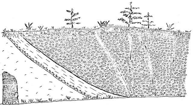 |
| Figure 5. Sketch of the exposure of upland gravels at Stop No. 4. Exposure is approximately 30 feet high. |
| Mileage Between Points |
|
| 0.2 | STOP No. 4. DEEP ROAD CUT. A cut about 30 feet deep on the right (north) side of U.S. 60 exposes coarse, upland gravels which overlie a seprolite of the Petersburg granite in a nonconformity. A sketch of this exposure is shown in Figure 5. The contact between the gravels and the granite dips eastward at 10 to 15 degrees and at this point varies in elevation from 340 to 350 feet. Immediately above the contact discoidal cobbles are oriented parallel to the contact but higher in the gravel sequence the cobbles have their maximum dimensions nearly horizontal, suggesting that this exposure may represent a former channel which had been cut in the granite surface and subsequently filled by the gravels. The Petersburg granite outcrops near the base of the western end of the exposure. The granite has been deeply weathered and completely converted to saprolite in which the feldspars have been thoroughly altered to clay. The original texture of the rock can be seen but only a few solid grains of quartz remain. A ten-foot wide, basic dike cutting the granite has also been completely converted to saprolitec The granite-gravet contact is sharp to gradational due to slight mixing and is overlain by a thin cobble zone varying from three inches to a foot in thickness. Above the cobble zone is a pronounced four-foot thick clay zone. The clay is very slightly silty, is massive on fresh exposures, but shows thin laminae on weathered surfaces, and is yellowish-brown with streaks of reddish-brown occurring as clay coatings on fracture planes. The upper surface of the clay is inclined eastward at 10 to 15 degrees sad is marked by a thin ferricrete zone about one-half inch thick. Above the clay is 25 feet of coarse gravel with a medium-to coarse-sand matrix. Most of the cobbles and pebbles are matrix supported and the clay which is present is derived primarily from decay of feldspar s. The gravels are white to deep reddish-brown. Most of the clasts are iron stained but the matrix is not. In general the clasts are well-rounded but have a sphericity ranging from low to high. There is a faint parallelism of the discoidal clasts. Most of the clasts are of massive quartz, vein quartz, quartzite, or quartz sandstone. Many of the quartzite and sandstone clasts are highly decomposed and friable. The clasts attain a maximum dimension of 8 inches and the gravels are thick-bedded with no obvious grading of the bedding. The gravels are weakly cemented and iron staining is less pronounced in the lower part of the exposure. A pronounced deep reddish-brown, clay filled fracture six inches wide cuts diagonally across the face of the exposure. At the top of the exposure is a strongly hematitic, deep reddish-brown zone of abundant pebbles and cobbles in a clay matrix. Very little sand or silt is present and many of the clasts are decomposed. Several of the quartz pebbles are stained on the outside but are fresh on the inside. Continue west on U.S. 60. |
| 0.4 | In the small roadcut exposure to the right (north) is a nonconformity between Triassic arkose and the Petersburg granite. This marks the eastern border of a small basin of Triassic sediments which lies to the east of the main Richmond basin. The western border of this small basin is marked by a normal fault immediately west of Falling Creek where the creek crosses U.S. 60. Several small exploratory pits have been dug in the Triassic coals of this basin and these pits as well as several deep mines occur both to the north and to the south of U.S. 60. Although long abandoned, culm heaps from the coal mining endeavors yield specimens of Triassic plants and fish. A narrow area of Petersburg granite lies between this basin and the main body of the Richmond basin to the west. |
| 0.4 | A thin seam of Triassic coal is exposed in the small roadcut to the right (north). This seam is part of the coal measures of the Richmond basin, and is near the eastern margin of the basin. |
| 0.1 | Upland gravels overlie Triassic sediments in the small cuts at the intersection of U.S. 60 and Va. 677. The contact lies at an elevation of about 330 feet. Continue west on U.S. 60. |
| 0.5 | The town of Midlothian, Virginia was formerly a center for a coal mining industry based on the Triassic coals or the Richmond basin. The coal, consisting of a good grade bituminous, occurs on both the eastern and western borders of the Richmond basin. It is most extensively exposed on the eastern border where the Triassic sediments are nonconformable upon the Peters- burg granite. Normal faulting along the basin's western margin has locally caused the coal to occur at dentin. Coal was first reported in the Richmond basin in 1701 and the first active production took Place in the 1780's. The major centers of mining activity were near the towns of Gayton and Manakin north of the James River and the towns of Midlothian and Winterpock south of the James River. From 1842 to 1360 the mines around Midlothian were at the peak of their production and some of the mines exceeded Boo feet in depth. Production continued around Midlothian until about 1930. Since then production has become negligible and at the present time no coal is commercially produced near Midlothian or anywhere else in the Richmond basin. Much coal still remains within the ground, but it occurs in relatively thin seems overlain by weak roof rock. In the vicinity of Midlothian much of the coal measures and other Triassic sediments are mantled by upland gravels. |
| 1.7 | Observe the broad flat area on either side of U.S. 60. This is an isolated upland remnant of high level gravels. Note the dissection in all directions. |
| 2.4 | Turn left (south) onto Va. 652. |
| 0.2 | Mt. Sinai Baptist Church is on the right (west). Turn around in front of the church and return north on Va. 652. |
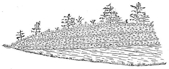 |
| Figure 6. Sketch of the exposure of upland gravels at Stop No. 5. Exposure is approximately 20 feet high. |
| Mileage Between Points |
|
| 0.2 | STOP No. 5. ROAD CUT. Park on right shoulder of Va. 652 just before its intersection with U.S. 60. Roadcuts about 20 feet high are on both sides of Va. 652. The west cut has been Dressed but the east cut undergoes continual slumping of the gravels above their contact with the underlying weathered Triassic shale. When first completed, this cut revealed an excellent contact between Triassic shale, dipping approximately 20 degrees to the east, and the upland gravels. The contact in the road cuts is nearly horizontal at an elevation of about 365 feet. A section in the grassed cut to the west reveals seven feet of Triassic shale and arkose overlain in angular unconformity by a one-foot bed of thin-bedded micaceous silty clay which is yellowish-brown mottled with whitish-gray. a thin pebble bed occurs at the base of this unit. Above the clay is a 1.3-foot thick bed of pebbles and large cobbles which are grain supported in a clayey matrix. The cobble bed is overlain by 1.5 feet of mottled brown and whitish-gray clay. This clay is covered by 12 feet of coarse gravels which are similar to the gravels making up most of the exposure at Stop No 4. This exposure marks the western limit of the upland gravels which underlie the town of Midlothian. However, outliers of the gravels occur on the summits of some of the hills further west. Turn right (east) onto U.S. 60, and retrace the route toward Midlothian. |
| 3.2 | Turn left (north) on Va. 714 (Winterfield Road). |
| 0.4 | Exposures of a upper Sandy member of the upland gravels occur in the railroad cuts to the right. |
| 0.3 | The low depression in the woods to the left is a small "Carolina Bay" about 0.3 mile in maximum diameter and trending northwest. |
| 0.3 | Turn right (east) on Va. 902 (Salisbury Road). Road cuts along this road expose the upper sandy member of the upland gravels. |
| 0.5 | Turn left (north) on Donington Road (Rt. 1012). |
| 0.5 | Turn right (east) on East Brigstock Road. |
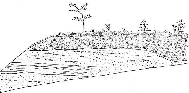 |
| Figure 7. Sketch of the exposure of upland gravels at Stop No. 6. Exposure is approximately 25 feet high. |
| Mileage Between Points |
|
| 0.3 | STOP No. 6. SALISBURY LAKE. East Brigstock Road comes to a dead end that overlooks a small lake. Park in the cul de sac and walk down the dirt path along the east side of the lake. A large vertical exposure of upland gravels overlying Triassic sedimentary rocks is found on the east side of this Path. This locality is on private property and care should be taken not to unduly disturb the area or the small pine trees which have been planted on the face of the exposure. A sketch of this exposure is given in Figure 6. The northern half of the exposure shows gently dipping, highly weathered shale and arkose of Triassic age in en angular unconformity with the nearly horizontal base of the overlying upland gravels. The contact becomes a disconformity in the southern half of the exposure. A generalized stratigraphic section of the Triassic saprolite shows seven feet of hematitic-red arkose at the base. This is overlain by 4.5 feet of shale which is grayish-brown grading upward to yellowish-brown to deep red. The shale is blocky and upon weathering splits into laminae. Locally the shale has arkosic lenses and elsewhere imprints of vegetation occur in the shale. Similar shale, exposed along the spillway of Salisbury Lake, contains abundant plant impressions and some fish scales. Above the shale is six feet of locally cross-bedded, locally pebbly, tight brownish-yellow arkose. In the southern half of the exposure both the lower arkose and the shale grade laterally into the cross-bedded arkose found at the top of the section. all of the Triassic sedimentary rocks have been deeply weathered and are saprolitic. The contact between Triassic saprolite and upland gravels is gradational and no clay bed occurs between the two. This is in contrast to Stops No. 4 and 5. At the left end of the exposure seven feet of upland gravels are exposed. Clasts range from pebbles to cobbles with several cobbles measuring nine inches in diameter. The clasts represent a highly mixed Ethology and many of the cobbles and pebbles are decayed. The general nature of the gravels is similar to that at Stops No. 4 and 5. They are weakly cemented and many discoidal pebbles and cobbles tend to lie with their flattened sides horizontal. At the right end of the exposure an additional 6.5 feet of highly oxidized, loamy gravels occur at the top. This grades upward into a clayey, sandy matrix with fleeting pebbles and cobbles that are highly decayed. The upper zone very possibly merely represents deeply weathered gravels. The Triassic-gravel contact at this locality lies at an elevation of approximately 340 feet. Retrace the route to the intersection of Donington Road and Salisbury Road (Va. 902). Turn left (east) on Salisbury Road. |
| 0.8 | Turn left on King's Lynn Road (Rt. 1010). Stop for a moment end look to the north across a large ''Carolina Bay" approximately 0.6 mile across. The intersection of Salisbury Road and King's Lynn Road is on the south rim of this bay and in the distance the north rim can be clearly seen beyond the depressed center of the bay. Continue north on King's Lynn Road. |
| 0.1 | At a sharp bend in the road, continue straight through an opening in the rail fence and follow the dirt road. Proceed with caution to the edge of a drainage ditch. |
| Mileage Between Points |
|
| 0.2 | STOP No. 7. CAROLINA BAY. This stop is within the
center of a "Carolina Bay." The bay has
developed on the upland gravels and is floored by them.
To the west is a golf course which has been recently
built. Since the golf course in part occupies this
"Carolina Bay" it was necessary to dig several
drainage ditches in order to remove excess water from the
course. This ditch is part of that drainage system. A
section exposed in the ditch to the east of the dirt road
shows 2.l feet of coarse gravel at the base. The gravels
are light gray to dark gray or brownish-black. Clasts
average two inches in diameter and attain maximum
dimensions of about six inches. Except for some of the
largest ones which have a horizontal elongation, the
clasts exhibit little preferred orientation. The matrix
is dominantly of clay with some sand, clay becoming more
abundant near the top. On exposure the clay matrix
becomes blocky and turns very light gray. The pebbles and
cobbles Ore dominantly of quartzite and vein quartz and
some have disintegrated. Chert is relatively rare. The
largest cobbles are most common near the top. Above the
gravel is four feet of massive, plastic, silty clay with
scattered siliceous pebbles and sand. The clay is
brownish-gray mottled with reddish-brown and becomes
darker upward with the introduction of organic material.
The upper 2.5 feet contains rootlets. In the ditch to the
west gravel continues to underlie silty clay. The contact
between the two units is irregular. Walk approximately 500 feet east along the north side of the drainage ditch to the end of the ditch. This locality is on the rim of the "Carolina Bay" end reveals a strikingly different stratigraphic sequence in the walls of the ditch. At the bottom is 3.9 feet of fine-to medium-sand with small pebbles scattered throughout. The sand is very slightly clayey, massive, and light gray with some hematite staining. It becomes indistinctly bedded upward with lenses of fine white sand interbedded with medium-to coarse-sand. The lower sand is gradational upward into 1.7 feet of medium-to coarse-sand which is very pebbly and friable. It is highly limonitic and the pebbles are sand supported. One large boulder measuring 12 by 4 by 7 inches was found in this sand. Patches of white pebbly sand are scattered throughout this unit but in general the pebbles diminish in numbers upward. Above the basal sand unit is a one-foot bed of gray, clayey send mottled with yellowish-brown and brownish-red. Modern rootless have made the upper portion of the clayey sand darker. At the top of the cut is 1.3 feet of silty clay with coarse sand and small pebbles. The pebbles are matrix supported. It is drab olive-brown in the lower oar t and grades upward to a light olive-brown. Shell developed thin bedding occurs in the upper part. As you walk westward along the bottom of the ditch observe the gradual change in Ethology. Approximately 125 feet to the west a section in the ditch shows four feet of massive, very slightly clayey, fine-to medium-sand at the base. It is pale reddish-brown mottled with white and contains a few scattered rounded quartz pebbles. This bed is overlain by about two feet of clayey, massive, fine sand with medium-to coarse-sand scattered throughout. The sand is gray mottled with brownish-red. A section in the ditch 15 feet further west shows 4.5 feet of massive, slightly clayey, fine-to medium-sand at the base. The sand is light-to medium-gray mottled with limonite and contains scattered rounded quartz pebbles. It is more pebbly near the base and more clayey near the middle. Above the sand is two feet of massive, olive-tan clay with small amounts of sand. A section 37 feet further to the west contains 4.3 feet of massive, slightly silty clay with minor sand and a few rounded quartz pebbles. It is medium-gray slightly mottled with reddish brown becoming darker gray downward. Locally the clay grades downward into sandy or pebbly clay. This bed is overlain by 1.5 feet of massive, olive-tan clay with very minor sand. In this traverse from east to west the lithology, of the upper beds has gradually changed from the sands of the rim to the clayey sediment of the bay's interior. Walk back to the intersection of the drainage ditch with the dirt road. Before boarding the vehicle took to the north and to the south. In both directions the raised rim of this "Carolina Bay" can be seen standing above the lower interior of the bay. Turn around and return to Radstock Road (a continuation of King's Lynn Road). Turn left (northeast) on Radstock Road. |
| 0.1 | Radstock Road curves around and follows the raised rim of the "Carolina Bay." |
| 0.3 | Turn right (east) on Stonegate Road ( Va. 1008). |
| 0.1 | Turn left (north) on Salisbury Road (Va. 902). The intersection of Stonegate Road and Salisbury Road is on the rim of another "Carolina Bay". The view to the north looks across this bay. |
| 0.2 | Another "Carolina Bay" lies immediately beyond the slightly raised rim to the left. |
| 0.3 | Turn right (southeast) on Va. 711. For a short distance Va. 711 follows the rim of another "Carolina Bay." |
| 1.7 | Stop at the intersection of Va. 711 and Va. 147. Turn left (north) on Va. 147. |
| 0.7 | Within the next 0.3 mile on the left the eroded remnants of two "Carolina Bays" can be seen. |
| 0.5 | Upland gravels are exposed in the slopes along the highway. |
| 0.8 | The housing development on the left has been built in a large "Carolina Bay. A view down the roads to the left within this development show the lower interior of the bay and the raised rim on the other side. Note the numerous drainage ditches which were necessary to remove the water from the low land in the bay's interior. |
| 1.5 | Upland gravels are exposed in the cuts on the right. Descend the slight scarp marking the northern edge of the upland gravels |
| 0.3 | Saprolite of Petersburg granite occurs in the cuts to the left. The upland gravels are absent. The elevation of the contact between gravel and granite is at about 255 feet.35. |
| 1.3 | Cross the James River. This is above the Fall Zone and outcrops of granite in the river's bed are sparce. Note the well-developed floodplain on the north side of the James River and the old canal on the floodplain. Continue on Va. 147. |
| 1.3 | Weathered granite is exposed in the cut on the left. |
| 0.1 | At stoplight continue to the right on Va. 147. |
| 0.2 | Turn left (north) on Libbie Avenue. Proceed north on Libbie Avenue, crossing Patterson Avenue and Monument Boulevard and continue to Broad Street (U.S. 250). |
| 1.7 | Turn right (east) on Broad Street (U.S. 250). |
| 0.8 | Turn left (north) on Staples Mill Road (US 33). |
| 1.1 | Turn right (east) on access road to I-64 East and then proceed east on I-64. |
| 1.3 | Bear right onto access road to I-95 South and proceed south on I-95. |
| 2.9 | Stop at toll booth and pay toll. |
| 0.6 | Bear right onto access road to I-64 East and then bear gradually left to enter I-64. Proceed east on I-64 and return to Norfolk. |
END of field trip.